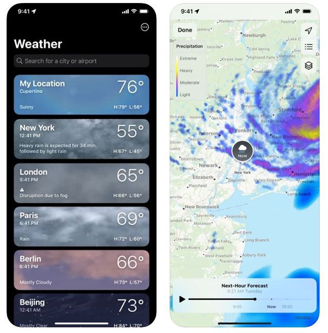
After Storm Arwen caused havoc in the UK, we are now bracing ourselves for up to two weeks of snow, ice and extremely freezing temperatures. Although we don't need to keep ourselves indoors just yet, iPhone users can turn to their Weather app to find out precise times and locations for any snowfall in your area.
MORE: The iPhone's secret Apple button you didn't know you needed
The Apple app allows users to view animated precipitation maps to see the path of a storm and intensity of upcoming rain and snow. You will also get the chance to explore air quality and temperature maps to see different conditions near you.
The Weather app can show a timeline of precipitation
All you have to do is make sure that you have the latest version of Apple's iPhone software: iOS 15 installed. Once that is sorted, open the map using the icon in the bottom-left corner of your screen to find Apple's Weather app.
MORE: 22 best tech gift ideas for Christmas 2021
Go into the app and tap the map icon in the bottom-left corner. Then tap the three squares stacked on top of each other in the top right.
You can see the path of a storm and intensity of upcoming rain in the app
Click on Precipitation and you'll be able to see a rolling forecast of snow and rain as it moves around you. Pan and zoom to view other areas of the map or use the list to quickly navigate to other saved locations.
When snow is imminent, you'll see an icon in the middle of the map over your location. Here you'll see when the snow is incoming, and how far it is away. As per the chart on the left, it shows different colours of the precipitation. Here, you'll be able to see if it's heavy or light flurries.
As with many apps, the predictions may not always be exactly right.
Like this story? Sign up to our newsletter to get other stories like this delivered straight to your inbox.


